India is strengthening its space-based surveillance with the launch of RISAT-1B (also called EOS-09), scheduled for May 18. This radar imaging satellite will be deployed using the PSLV-C61 XL variant from Sriharikota. The 1,710 kg RISAT-1B is the primary payload, accompanied by smaller secondary satellites.
Features of RISAT-1B
RISAT-1B is equipped with a C-band synthetic aperture radar (SAR), allowing it to conduct all-weather, day-and-night imaging of Indian territory. It will be placed in a sun-synchronous orbit at an altitude of 529 km. This marks ISRO’s seventh satellite in the RISAT series, following earlier launches like RISAT-2 (2009), RISAT-1, RISAT-1A, and others.
Dual-Use Capability
A former ISRO chairman noted that satellites with imaging capabilities, like RISAT-1B, can have both civilian and military applications, including disaster management and surveillance.
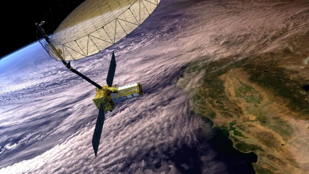
NISAR Launch Planned for June
Following RISAT-1B, ISRO is preparing for the June launch of the NISAR satellite — a joint collaboration between ISRO and NASA. The satellite will be launched aboard the GSLV-F16 rocket. Initial launch preparations began in April at the Sriharikota spaceport.
First-of-Its-Kind Dual-Band Satellite
NISAR is designed with dual-band SAR technology: NASA is contributing the L-Band SAR, while ISRO is providing the S-Band SAR. The satellite is not intended for surveillance but for detailed earth observation and scientific research.
Scientific and Environmental Applications
NISAR will monitor land deformation caused by natural disasters such as earthquakes, landslides, and volcanic activity. It will also study glacier movements, deforestation, wetlands, and the global carbon cycle. Scanning nearly all land and ice surfaces twice every 12 days, it will support sectors like disaster response, infrastructure monitoring, biomass estimation, and agriculture.
ISRO’s Focus on Indian-Specific Applications
ISRO has identified various applications aligned with national needs, including Himalayan glacier research, landslide monitoring, coastal wind patterns, soil moisture analysis, and hazard tracking.
Despite its radar imaging capability, ISRO emphasizes that NISAR will be used solely for scientific and environmental observation, not surveillance.